
When choosing the best LiDAR devices for precision mapping and surveying in 2025, I look for high accuracy, long range, and environmental durability. Devices like the RPLIDAR A1M8, WayPonDEV C1, and TFS20-L offer impressive performance with wide scanning angles and rugged designs for outdoor use. They support multiple interfaces and integration options, making them ideal for robotics, surveying, and environmental analysis. Keep exploring to discover which LiDAR solutions best suit your project’s needs.
Key Takeaways
- The top LiDAR devices of 2025 feature ranges from 8 to 30 meters with high accuracy for precise mapping.
- They support various technologies including laser triangulation, TOF, and integrated IMUs for robust outdoor and indoor use.
- Many models offer environmental resistance like IP54 waterproofing and anti-glare tech for durability in harsh conditions.
- Compatibility with robotics, SLAM, and software frameworks like ROS ensures seamless integration into mapping workflows.
- These sensors cater to applications such as autonomous navigation, surveying, obstacle detection, and environmental analysis.
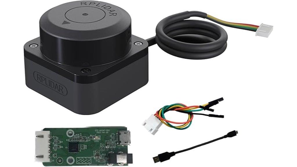
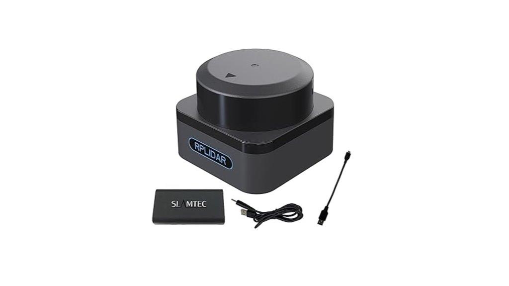
RPLIDAR A1M8 2D 360° LIDAR Sensor for Robots

If you’re looking for an affordable yet reliable 2D laser scanner for robot navigation, the RPLIDAR A1M8 is an excellent choice. It provides 360-degree scanning with a 12-meter range, perfect for obstacle detection and environment mapping. Setup is straightforward thanks to its plug-and-play design, and it’s compatible with M2.5 mounting screws for easy integration. Operating on just 5V, it offers configurable scan rates from 2 to 10Hz, ensuring flexibility. With an impressive 8,000 samples per second, it guarantees precise data collection. Built with durable materials, the A1M8 is suitable for continuous use in various environments, making it ideal for autonomous robots.
Best For: robotics enthusiasts and developers seeking an affordable, reliable 2D laser scanner for obstacle avoidance and environment mapping.
Pros:
- High sampling rate of 8,000 samples per second ensures precise data collection.
- 360-degree omnidirectional scanning ideal for comprehensive environmental mapping.
- Plug-and-play setup with M2.5 mounting compatibility simplifies integration.
Cons:
- Limited to a 12-meter range, which may not suit large-scale outdoor applications.
- Operates solely on 5V power, possibly requiring additional power management in complex systems.
- Primarily designed for 2D scanning, not suitable for 3D mapping tasks.
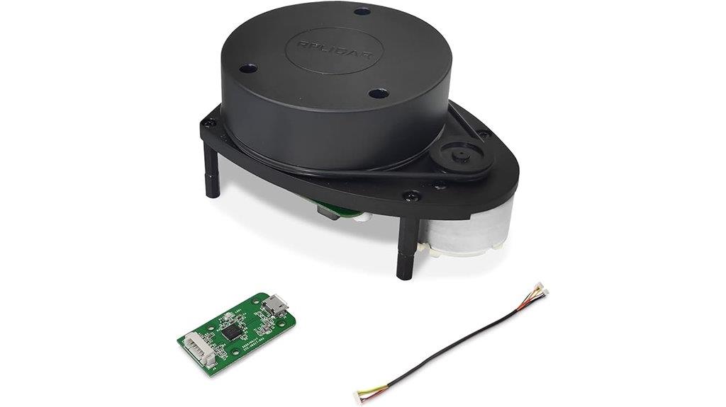
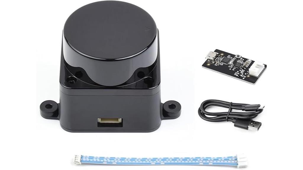
Slamtec RPLIDAR A1M8-R6 with MX1.25 to 2.54 Dupont Wire Kit
The Slamtec RPLIDAR A1M8-R6 with MX1.25 to 2.54 Dupont Wire Kit is an excellent choice for developers and hobbyists seeking a compact, long-range 2D LiDAR sensor that delivers high-resolution data. It scans 360 degrees up to 12 meters, capturing over 8,000 data points per second, perfect for navigation, obstacle avoidance, and SLAM. The kit includes the sensor, USB adapter, and Dupont wires, making integration straightforward with Jetson Nano, Raspberry Pi, or Arduino. Its lightweight design and extensive support resources make it versatile for various robotic platforms, ensuring reliable performance for precise mapping and surveying tasks.
Best For: developers and hobbyists seeking a reliable, high-resolution 2D LiDAR sensor for robot navigation, obstacle avoidance, and SLAM applications.
Pros:
- Provides 360-degree omnidirectional scanning with a range of up to 12 meters.
- Captures over 8,000 data points per second for detailed mapping.
- Includes a comprehensive kit with USB adapter and Dupont wires for easy integration with various platforms.
Cons:
- Customer ratings average only 3.1 out of 5 stars, indicating mixed reviews.
- Slightly larger and heavier compared to some compact sensors, which may impact smaller robot designs.
- Requires some technical knowledge for setup and software integration despite extensive tutorials.
RPLIDAR A1M8 2D 360° 12m LIDAR Sensor for Robots
Looking for an affordable yet dependable LiDAR sensor that can handle obstacle detection and navigation tasks? The RPLIDAR A1M8 offers a 2D, 360-degree scanning capability with a 12-meter range, making it ideal for robotics applications. It features a plug-and-play setup and operates on just 5V, with configurable scan rates between 2-10Hz. Thanks to its high sampling rate of 8,000 samples per second, it provides precise, consistent data. Its robust design guarantees durability for continuous use in various environments. Whether you’re working on autonomous navigation or obstacle avoidance, this sensor delivers reliable performance at a budget-friendly price point.
Best For: robotics enthusiasts and developers seeking an affordable, reliable LiDAR sensor for obstacle avoidance and navigation in autonomous systems.
Pros:
- High sampling rate of 8,000 samples per second ensures precise data collection.
- Easy plug-and-play setup compatible with standard mounting options.
- Robust design and 12-meter range suitable for various environments and continuous use.
Cons:
- Limited to 2D scanning, which may not suffice for complex 3D mapping.
- Operates only within a 5V power supply, requiring compatible power sources.
- Scan rate configurable only between 2-10Hz, which might limit high-speed applications.
WayPonDEV RPLIDAR C1 360° 2D Lidar Sensor
Are you seeking a reliable and precise LiDAR sensor for obstacle avoidance and navigation? The WayPonDEV RPLIDAR C1 offers a 360-degree scanning range up to 12 meters, with an impressive angular resolution of 0.72°. Its high accuracy of ±15mm and fast scanning frequency of 8-12Hz make certain responsive performance. Lightweight at just 110 grams, it’s easy to integrate into various robotic platforms, with IP54 dust and water resistance for outdoor use. Compatible with ROS and other systems, this sensor combines triangulation and TOF technologies for reliable environmental mapping, making it ideal for indoor and outdoor navigation, environmental scanning, and robot positioning.
Best For: robotics developers and engineers seeking a high-precision, reliable LiDAR sensor for obstacle avoidance, navigation, and mapping in both indoor and outdoor environments.
Pros:
- High accuracy of ±15mm with a 0.72° angular resolution for precise environmental sensing
- Supports up to 12 meters range with a fast 8-12Hz scanning frequency for responsive operation
- Lightweight and compact (110 grams) with IP54 dust and water resistance, ensuring easy integration and durability
Cons:
- Requires a compatible power supply (battery not included), adding to overall setup complexity
- Limited to 2D scanning, which may not suffice for applications needing 3D environmental data
- Compatibility and SDK support are primarily focused on Windows and Linux systems, which may limit users on other platforms
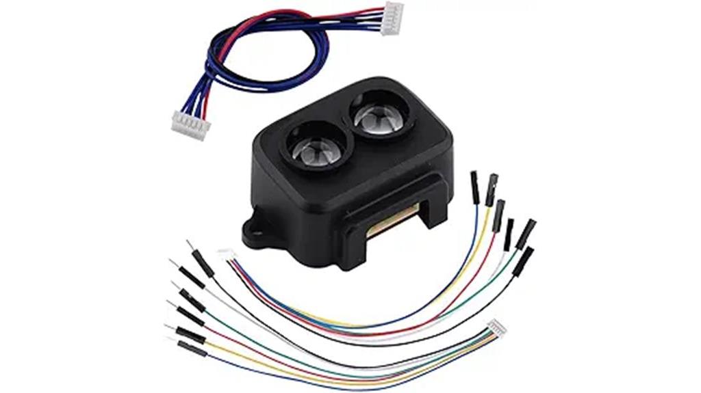
WayPonDEV TFS20-L Lidar Sensor Scanner for Robots and Drones

If you’re designing compact robots or drones that require precise distance measurement, the WayPonDEV TFS20-L LiDAR sensor is an excellent choice. It offers accurate long-range readings from 0.2 to 20 meters, with ±6cm accuracy up to 6 meters, even in bright sunlight. Its small size (21×15×7.87mm) and light weight (1.35g) make it ideal for micro-sized applications. Supporting I²C and UART interfaces, it easily integrates with platforms like Arduino or Raspberry Pi. The sensor’s robust design guarantees reliable operation outdoors and indoors, making it perfect for obstacle avoidance, UAV navigation, and IoT projects requiring high performance in compact form factors.
Best For: micro-robotics, drone navigation, and IoT projects requiring compact, precise long-range distance sensing.
Pros:
- Compact and lightweight design ideal for small-scale applications
- High accuracy (±6cm up to 6 meters) even under bright ambient light
- Supports multiple interfaces (I²C and UART) for easy integration with popular development platforms
Cons:
- Limited to 20 meters maximum range, which may not suit long-distance needs
- Requires external power source; does not include batteries
- Small size might necessitate careful handling during installation
WayPonDEV LD14P 2D 360° Lidar Sensor for Robot Navigation
The WayPonDEV LD14P 2D 360° Lidar Sensor is an excellent choice for robotic applications that demand precise environment detection and obstacle avoidance. It uses triangulation technology to deliver high-precision mapping and real-time obstacle detection, making it ideal for navigation, autopilot, and mapping tasks. With a range of up to 8 meters on white targets and a 6Hz scanning frequency, it provides detailed 4000 points per second. Its compact, lightweight design features anti-glare technology to operate reliably even in bright sunlight. Built for durability, it withstands harsh environments, ensuring consistent performance for long-term autonomous robot operation.
Best For: robotic developers and engineers seeking a high-precision, durable 2D laser sensor for navigation, obstacle avoidance, and environmental mapping in both indoor and outdoor environments.
Pros:
- High-precision measurement with a range up to 8 meters on white targets and real-time 4000 points per second scanning.
- 360° field of view with adjustable pitch angle, suitable for comprehensive environment detection.
- Robust design with anti-glare technology, dust cover, and environmental resistance for reliable long-term outdoor and indoor operation.
Cons:
- Limited maximum distance on black targets (6 meters), which may affect applications in low-reflectivity environments.
- Operating temperature range (-10°C to 50°C) may restrict use in extreme cold or hot conditions.
- Slightly higher complexity in integration due to the need for compatibility with specific algorithms and potential calibration.
WayPonDEV 360 Degree 2D Lidar Sensor Kit
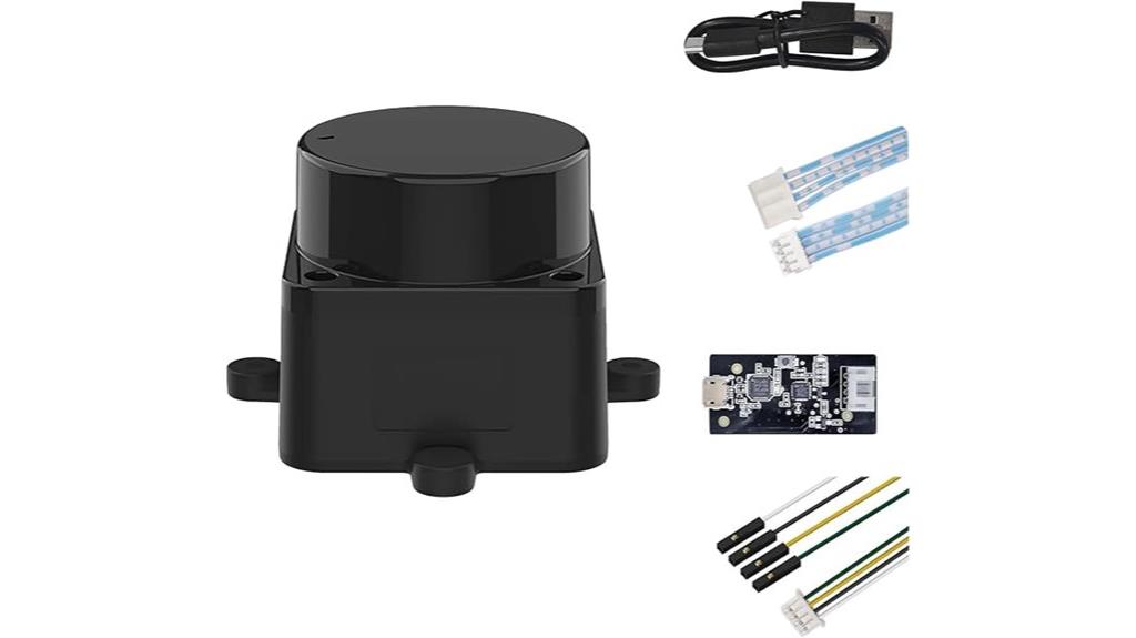
For robotics enthusiasts and developers seeking an affordable yet capable 360-degree Lidar solution, the WayPonDEV FHL-LD19 stands out. It offers a high sampling rate of 8,000 times per second and a maximum range of 12 meters for white objects with 70% reflectivity. Its compact, lightweight design (0.17 kg) and IP54 waterproof rating make it suitable for indoor and outdoor use. The sensor features plug-and-play USB and serial interfaces, open-source SDKs, and ROS compatibility, simplifying integration. Ideal for obstacle detection, navigation, SLAM, and environment mapping, it’s a versatile choice despite some software limitations affecting SLAM performance.
Best For: robotics enthusiasts, developers, and educators seeking an affordable, easy-to-integrate 360-degree Lidar sensor for obstacle detection, navigation, and environment mapping.
Pros:
- High sampling rate of 8,000 times/sec for detailed environmental scanning
- Compact, lightweight design with IP54 waterproof rating suitable for indoor and outdoor use
- Plug-and-play with USB and serial interfaces, open-source SDKs, and ROS compatibility for easy integration
Cons:
- Software driver issues lead to inconsistent scan readings, impairing SLAM functionality
- Limited firmware support and manufacturer response hinder full feature utilization
- Current driver does not conform fully to expected range and angle data specifications
LDROBOT D500 Lidar Kit for Outdoor Robot Navigation
Designed for outdoor robotics, the LDROBOT D500 Lidar Kit stands out with its high accuracy and durable performance, making it an ideal choice for applications requiring reliable environment mapping and obstacle detection. It supports ROS1 and ROS2, ensuring seamless integration into various robotic systems. Its compact size and low power consumption enhance passability and efficiency, while the brushless motor provides 360-degree scanning and detailed point cloud data. With a lifespan of up to 10,000 hours, it offers long-term stability and minimal maintenance. The D500’s advanced outdoor SLAM capabilities make it perfect for precise navigation in challenging environments.
Best For: outdoor robotics developers and engineers seeking reliable, high-precision SLAM navigation and obstacle detection solutions in challenging environments.
Pros:
- High ranging accuracy with ±10mm error over 0.03 to 0.5m range
- Durable with a lifespan of up to 10,000 hours and quiet brushless motor
- Compact, stylish design with low power consumption for easy integration
Cons:
- May require technical expertise for optimal setup and integration with ROS systems
- Limited details on advanced features beyond basic outdoor SLAM and obstacle detection
- Potential higher cost compared to simpler or lower-precision lidar options
WayPonDEV Unitree L2 4D 3D Lidar Sensor Scanner
If you’re seeking a compact, high-precision LiDAR sensor capable of detailed 3D mapping in outdoor environments, the WayPonDEV Unitree L2 4D 3D Lidar Sensor Scanner is an excellent choice. It offers 360° horizontal and 96° vertical scanning with a 30-meter range, supporting high sampling rates of 128K points/sec. Its integrated 3-axis IMU enhances stability, while its omnidirectional scanning captures detailed point clouds suitable for mapping, navigation, and environment recognition. Designed for outdoor use, it performs well under bright lighting and maintains stable operation. Easy to integrate via Ethernet or TTL UART, this sensor is ideal for robotics, smart city, and obstacle avoidance applications.
Best For: robotics, outdoor mapping, and environment recognition professionals seeking a compact, high-precision 3D LiDAR sensor for detailed scanning and autonomous navigation.
Pros:
- Supports 360° horizontal and 96° vertical omnidirectional scanning for comprehensive environment coverage
- High sampling rate of 128K points/sec ensures detailed and accurate 3D data collection
- Integrated 3-axis IMU enhances stability and precision during outdoor mapping and navigation
Cons:
- Requires external power supply as it does not include batteries
- Limited to pole mounting, which may restrict certain deployment options
- Slightly bulky size (75×75×65 mm) may pose integration challenges in space-constrained setups
TF-Luna LiDAR Range Finder Sensor (0.2m-8m, UART/I2C, 6Pin Terminal to Dupont Cable)
The TF-Luna LiDAR Range Finder Sensor stands out as an ideal choice for robotics enthusiasts and developers seeking a compact, accurate, short-range sensing solution. Operating between 0.2 and 8 meters, it provides 1 cm resolution with a maximum range of 8 meters. Weighing under 5 grams and powered by 5V, it consumes only 0.35W. Its VCSEL laser at 850nm ensures reliable measurements, while UART and I2C interfaces offer flexible connectivity. With adjustable frame rates up to 250Hz and compatibility with microcontrollers like Raspberry Pi Pico and Pixhawk, it’s perfect for obstacle detection, level measurement, and safety applications in compact robotics.
Best For: robotics enthusiasts, developers, and hobbyists seeking a compact, accurate short-range LiDAR sensor for obstacle avoidance, level measurement, and safety applications.
Pros:
- High accuracy with 1 cm resolution within an 8-meter range.
- Lightweight design (under 5 grams), ideal for embedded and mobile applications.
- Flexible connectivity options with UART and I2C interfaces for various microcontrollers.
Cons:
- Limited to short-range measurements up to 8 meters.
- Requires external 5V power supply and wiring setup, which may be complex for beginners.
- No onboard processing or advanced features beyond basic distance measurement.
WayPonDEV RPLIDAR S3 Lidar Sensor for Robot Navigation
Looking for a reliable LiDAR sensor that excels in both indoor and outdoor navigation? The WayPonDEV RPLIDAR S3 offers laser SL-TOF technology with a 32KHz frequency, measuring distances from 0.05 to 40 meters. It provides a scan rate of 10-20Hz with high resolution, ensuring precise mapping and obstacle detection. Its strong light adaptability allows it to perform well in challenging environments, including direct sunlight and various surface colors. Easy to set up with plug-and-play USB and serial interfaces, it integrates smoothly with ROS and open-source SDKs. Perfect for SLAM, robotic navigation, and long-term applications, the S3 is a versatile choice.
Best For: robotics developers and researchers seeking a versatile, high-precision LiDAR sensor for indoor and outdoor navigation and mapping applications.
Pros:
- High accuracy with 0.15°-0.18° resolution and 32KHz laser technology for precise measurements.
- Strong light adaptability enabling reliable operation in challenging environments like direct sunlight and varying surface colors.
- Easy plug-and-play setup with USB and serial interfaces, supporting ROS and open-source SDKs for seamless integration.
Cons:
- Limited maximum range of 40 meters, which may be insufficient for some large-scale outdoor applications.
- Slightly higher cost compared to simpler LiDAR sensors, potentially impacting budget-conscious projects.
- Requires compatible hardware and software environments for optimal use, which might involve additional setup.
Factors to Consider When Choosing Lidar Scanning Devices
When selecting a LiDAR scanning device, I focus on key factors like range capabilities, measurement resolution, and environmental resistance. I also consider power needs, connectivity options, and the device’s size and weight to guarantee it fits my application. Understanding these points helps me choose the right sensor for reliable and efficient performance.
Range Capabilities and Limits
Have you ever wondered how far a lidar device can see? The range varies considerably, from as little as 0.2 meters to over 40 meters, depending on the technology. Longer-range lidars can cover large areas but often sacrifice resolution and are more affected by environmental factors like fog, rain, or bright sunlight. Short-range lidars excel in capturing detailed data at close distances but can’t scan extensive environments effectively. Surface reflectivity also impacts range; reflective surfaces increase detection distance, while dark or matte surfaces reduce it. When choosing a lidar, think about your specific needs—whether you require long-distance coverage or detailed close-up scans. Matching the device’s range capabilities with your operational environment is essential for maximum performance.
Measurement Resolution Details
How do you determine the level of detail a lidar device can capture? It all comes down to measurement resolution, which includes angular and range resolution. Angular resolution, measured in degrees, shows how well the lidar can distinguish between objects at different angles within its scan area. Range resolution, expressed in millimeters or centimeters, indicates how precisely it can differentiate between objects at similar distances. Higher resolution means more detailed environmental mapping and better obstacle detection, especially in cluttered environments. Factors like sensor design, scanning rate, signal-to-noise ratio, and environmental conditions such as surface reflectivity or ambient light can influence performance. When choosing a lidar, consider these resolution aspects to ensure your device meets your specific accuracy and detail requirements.
Environmental Resistance Features
Choosing a lidar device for outdoor applications requires careful attention to its environmental resistance features. An IP54 rating or higher is crucial for dust and water protection, ensuring durability in harsh conditions. Sunlight resistance is equally critical; some lidars can operate reliably in ambient light levels up to 80,000 lux, minimizing interference from bright sunlight. A robust optical design with anti-glare and anti-disturbance features helps maintain accuracy in reflective or luminous environments. High ambient light resistance allows lidar sensors to function effectively outdoors without signal degradation. Additionally, durable construction with weatherproof features ensures long-term operation despite dust, water, and temperature fluctuations. These environmental resistance features are essential for reliable, precise mapping and surveying in diverse outdoor conditions.
Power and Connectivity Options
When selecting a LiDAR device, understanding its power and connectivity options is crucial to guarantee smooth integration with your system. I look for compatible power inputs like 5V DC, 12V DC, or USB power, depending on my platform’s capabilities. It’s essential to verify if the device supports multiple communication interfaces such as UART, I2C, SPI, USB, or Ethernet to match my system’s needs. I also consider whether integrated or external cables and connectors, like Dupont wires or USB adapters, are available for seamless setup. Wireless options like Wi-Fi or Bluetooth are helpful for remote data transfer, especially in mobile applications. Finally, I ensure the device’s power consumption aligns with my energy constraints, particularly when working with battery-powered or portable systems.
Size and Weight Factors
The size and weight of a LiDAR sensor play a critical role in how easily it can be integrated into your robotic system. Smaller, lighter sensors are much easier to incorporate into compact platforms, enhancing maneuverability and reducing overall payload. For mobile robots, the physical dimensions and weight directly influence design flexibility and energy efficiency. Lightweight units, often under 200 grams, are perfect for drones and handheld tools where portability is essential. A compact size also enables seamless mounting on various surfaces without blocking other sensors or components. Additionally, a smaller form factor allows for installation in tight spaces and complex assemblies, expanding potential use cases. When choosing a LiDAR, consider how its size and weight will fit into your system’s design and operational requirements.
Software Compatibility Ease
Are you confident that your LiDAR device will integrate smoothly with your existing software setup? Compatibility is vital for efficient workflows. I look for devices that offer SDKs or APIs compatible with my preferred programming language and operating system, whether Windows, Linux, or RTOS. It’s also essential that the device supports integration with popular robotics frameworks like ROS or ROS2, or easily connects with custom middleware. Regular firmware and driver updates from the manufacturer ensure ongoing compatibility as software evolves. I also check that SDK documentation includes clear examples, tutorials, and troubleshooting tips to streamline implementation. Additionally, community support, forums, and technical assistance can make resolving integration issues quicker and less frustrating. Prioritizing software compatibility saves time and maximizes the device’s value.
Environmental Suitability Needs
Choosing a LiDAR device isn’t just about software compatibility; environmental factors play a *crucial* role in *ensuring* reliable performance. I consider how well the sensor resists ambient light interference, especially in bright sunlight up to 80,000 lux, to maintain accuracy outdoors. Dust and water resistance are also *vital*—look for ratings like IP54—to withstand dusty or wet conditions. The device’s operating temperature range, such as -10°C to 50°C, must align with the deployment environment. Additionally, anti-glare or anti-disturbance technologies help preserve data integrity in bright outdoor settings. *Lastly*, durability against vibration, dust, and water ensures the sensor remains reliable during tough conditions. Evaluating these factors guarantees the LiDAR performs consistently, regardless of environmental challenges.
Cost and Budget Considerations
Cost and budget considerations are fundamental when selecting a LiDAR device, as prices can vary markedly—from affordable models around $100 to premium systems exceeding $10,000. It’s imperative to account for the total cost, including accessories like cables, mounting brackets, and power supplies, which can add considerably to expenses. Higher-priced Lidars typically offer better measurement range, resolution, and reliability, essential for demanding tasks. Budget constraints often influence the choice between different technologies, such as TOF, triangulation, or hybrid systems, each with distinct costs. When selecting a device, I find it crucial to balance the initial purchase price with long-term expenses like maintenance, durability, and software support. This approach ensures a cost-effective investment aligned with project needs and financial capacity.
Frequently Asked Questions
How Do Lidar Devices Differ in Accuracy for Various Terrains?
Lidar devices vary in accuracy depending on terrain, and I’ve noticed significant differences. For flat, open areas, accuracy is usually higher because the laser can reflect cleanly back. In dense forests or rugged terrain, accuracy drops due to vegetation, obstructions, or uneven surfaces. I always choose a device with higher pulse rates and better resolution for challenging terrains, ensuring I get the most precise data possible.
What Is the Typical Lifespan of a Lidar Sensor Under Heavy Use?
Did you know a LiDAR sensor can last over 10,000 hours of heavy use? Under such demanding conditions, I’d expect the lifespan to be around 3 to 5 years, depending on maintenance and operational environment. Regular calibration and careful handling can prolong this. I always recommend checking the manufacturer’s guidelines, as proper care ensures your sensor stays accurate and reliable longer, saving you time and money in the long run.
Can These Lidar Devices Operate Effectively in Extreme Weather Conditions?
Yes, many LiDAR devices can operate effectively in extreme weather, but it depends on the model and build. I’ve found that ruggedized units with weatherproof housings perform well in rain, snow, or dust. However, heavy precipitation or fog can still diminish accuracy. I recommend choosing LiDAR sensors specifically designed for harsh conditions to guarantee reliable data collection in challenging environments.
How Do Power Requirements Vary Among Different Lidar Models?
Power needs in lidar models are like the fuel that drives a vehicle; some require high energy, demanding robust batteries or external sources, while others are more energy-efficient, suited for long, remote surveys. I’ve noticed that advanced models with higher precision often consume more power, reflecting their complex sensors and processors. Choosing the right lidar depends on your project’s power supply capabilities and the balance between performance and energy consumption.
Are There Compatibility Concerns When Integrating Lidar With Other Mapping Tools?
Yes, compatibility can be a concern when integrating LiDAR with other mapping tools. I always check if the device supports common data formats like LAS or LAZ, and whether it can connect seamlessly with software I use. Sometimes, drivers or firmware updates are needed to guarantee smooth operation. Being aware of these factors helps me avoid technical hiccups and get accurate, integrated mapping results.
Conclusion
After exploring these top lidar devices, I realize choosing the right one depends on your specific needs. For instance, a surveying firm might opt for the RPLIDAR A1M8 for its accuracy, while a robotics startup could prefer the WayPonDEV TFS20-L for versatility. I’ve seen companies increase mapping precision by integrating these sensors, proving that selecting the right lidar can truly transform your project’s success.